They gave us a wave: satellites taught us how to find "invisible" plastic in the ocean
- Статьи
- Science and technology
- They gave us a wave: satellites taught us how to find "invisible" plastic in the ocean

Russian scientists have proposed a new way to detect plastic debris hidden under the surface of the ocean. The method is based on the fact that its clusters change the structure of wind waves, and these changes can be recorded using satellite images. During the experiments, the researchers tested the development and for the first time calculated the so—called plastic index, a computational indicator that automatically detects signs of pollution in water areas when analyzing images from space. Among the limitations of the technology, experts cited the narrow range of wind speed in which the method is applicable, and the difficulty of distinguishing plastic from biogenic and petroleum films.
How to distinguish between accumulations of debris from space
Scientists from the A.V. Gaponov-Grekhov Institute of Applied Physics have calculated the "plastic index" for the first time in the world. The new tool will make it possible to accurately identify accumulations of debris in large water areas. The development will help improve the ecology of large reservoirs and the World Ocean.
— One of the main problems of plastic in the sea is related to the fact that a significant part of it "floats" in the subsurface layer. Waves seem to "push" such objects into the upper layers of water and hold them due to special hydrodynamic processes. As a result, huge amounts of garbage are hidden from view," Stanislav Ermakov, head of the Department of Radiophysical Methods in Hydrophysics at the IPF RAS, explained to Izvestia.
But even if the plastic is "hidden" under water, it still gives itself away, the scientist explained. For example, when its clusters are closer to the surface, they dampen wind waves, and the surface becomes smooth, which looks like a dark spot in the images. If the plastic is deeper, it can fluctuate, which provokes small ripples that appear in the images as bright areas.
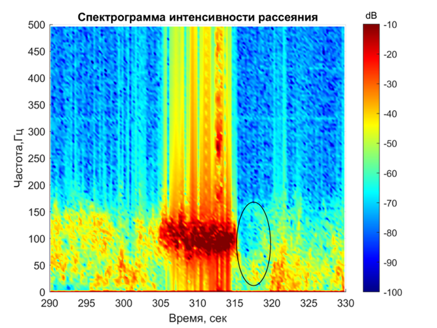
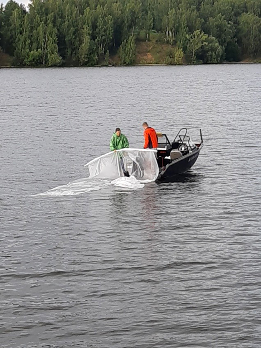
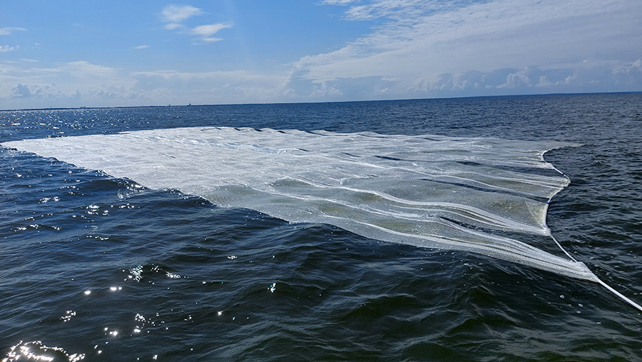
Experimentally, scientists have studied these processes at the Gorky reservoir. They laid out plastic sheets up to 450 square meters in size on the water (like a basketball court) and recorded changes in surface properties with instruments. The observations were carried out from aboard a research vessel and using orbiters, Stanislav Ermakov said.
— Based on the research results, we were able to evaluate the "plastic index". This is an indicator that helps to find clusters of this type of object in satellite images taken in different ranges of the optical spectrum. We have obtained an index that is consistent with the data in the world scientific literature," he added.

How much plastic ends up in the World's oceans
The model was tested on radar images from orbit, which were taken after the devastating 2011 tsunami in Japan, when millions of tons of debris fell into the ocean. Bright areas are clearly visible on them — accumulations of debris and plastic. The calculations made using the proposed index coincided with what the spacecraft saw from space.
If the technology can be developed, the expert explained, satellites will be able to find polluted areas faster and track the movement of debris in large water areas in real time. This means that the chances of effectively combating plastic pollution in the oceans will increase.
At the same time, according to the researchers, plastic quickly becomes overgrown with microorganisms and algae in water, which forms a so-called plastisphere. These ecosystems develop right on the surface of the garbage. Improving the methodology in the future will make it possible to monitor such communities.
— 12.7 million tons of plastic are released into the environment every year. Eventually, it either gets buried in the ground, or it is carried out into the open ocean, where so—called garbage islands are formed due to global currents," Alexander Tsvetkov, a researcher at the Laboratory of Hydrology and Hydrochemistry at the I.D. Papanin Institute of Biology of the Russian Academy of Sciences, told Izvestia.
The analysis of structural changes in wave currents to identify plastic accumulations will be effective when using machine learning algorithms, the expert noted.
Ocean pollution is especially noticeable in small island states, where such debris is carried in large quantities by currents. Even thorough cleaning of the shores does not help, because the ocean again delivers plastic from other areas, said Igor Zhdanov, a researcher at the Laboratory of Ocean-Land Interaction and Anthropogenic Processes at the P.P. Shirshov Institute of Oceanology of the Russian Academy of Sciences.
Currently, according to him, the distribution of plastic in the ocean is mainly studied through ship observations. The new method will improve the mapping of garbage accumulations and help track their dynamics.
— The proposed solution is a type of remote sensing through the modulation of the spectrum of short wind waves. The submerged plastic suppresses gravitational capillary waves 1-30 cm long. This appears as dark spots on radar images. The same effects underlie the detection of oil films and calm zones from space," said Evgeny Vishnevsky, NTI expert on new materials and technologies.
According to him, the value of the development is not the very fact of detecting effects, but the quantitative calibration of the effect through experiment and the binding of the optical "plastic index" to a real target. The limitations of the method include the difficulty of identifying data, since the dark spot in the image may be oil, biogenic film, rain squall, or a wind lull zone. In addition, the method works in a narrow window of wind speed — about 3-8 m/s.
Переведено сервисом «Яндекс Переводчик»
