Full flight: geostationary satellite will help drones master long-range routes
- Статьи
- Science and technology
- Full flight: geostationary satellite will help drones master long-range routes

In Russia, for the first time, the control of unmanned aerial vehicles via satellite in geostationary orbit was tested at an altitude of about 36 thousand km. Previously, low—orbit groupings were used for these tasks. In contrast, geostationary satellites provide more stable and continuous communications due to their wide coverage. The technology opens up opportunities for creating long—range unmanned aircraft routes, from remote monitoring of vast territories to the delivery of mail and various cargoes. For more information about the technology, see the Izvestia article.
How to control drones through geostationary orbit
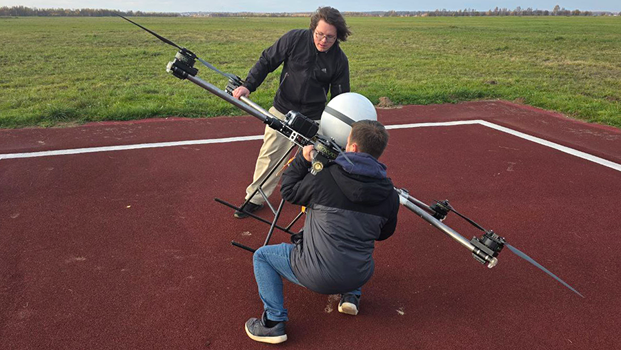
Scientists from the Moscow Aviation Institute (MAI) have developed and tested a UAV control system via a geostationary satellite. The new technology will allow drones to be controlled over vast distances, beyond direct radio visibility. This paves the way for the creation of unmanned logistics in remote parts of the country.
The research was conducted jointly with Gazprom Space Systems JSC and Reshetnev JSC (part of Roscosmos State Corporation) within the framework of the Priority 2030 program and the Seamless Operating Environment project. Its purpose is to ensure the uninterrupted exchange of information between space, air and ground objects.
— The growth of the UAV market has revealed the need for their management "beyond the horizon". Currently, most of these systems are limited to direct radio visibility — up to 40-50 km. Control via high-altitude space satellites will multiply the range of the devices. This, in turn, will give an impetus to the development of the field of unmanned vehicles. The flight range will be limited only by its resource," said the project manager, Deputy Director of the Space Technology Center MAI Alexander Turov.
He explained that the advantage of geostationary communications is its high stability. Such satellites hover above the Earth at a single point, providing extensive coverage and a constant, reliable communication channel. At the same time, low-Earth orbiters monitor a much smaller area. In addition, they are in constant motion, which requires switching between them and complicates data transfer protocols.
According to the scientist, technically, communication with the geostationary is provided by a terminal on board the drone. Initially, the device was designed to provide subscribers with a stable signal in conditions of limited mobile Internet access and cellular coverage. The terminal is equipped with an antenna that automatically targets a satellite in geostationary orbit.

Where long-range unmanned routes are in demand
However, according to Alexander Turov, real-time control of equipment via a high-altitude satellite faces a number of difficulties. In particular, the signal delay is 0.25 seconds. This makes it impossible to control the drone in real time, which is critical for tasks that require an instant response. For example, video transmission, direct piloting.
To solve the problem, the designers used director management algorithms, the scientist said. The essence of the method is that the operator does not transmit commands to the drone in real time, but sets coordinates or waypoints for it. Next, the device independently executes the instructions received, relying on its own actuators and navigation system.
— The test program consisted of three stages, — explained Nikita Matasov, Project Manager of the MAI CCT. — The first one is testing the terminal and verifying its compliance with technical requirements. During the second stage, the scientists worked out the integration of the satellite system on the drone and checked the constructive, electrical and software compatibility of the terminal with the drone. The final stage included flight tests at the airfield.
According to the results of the research, the suitability of the equipment was confirmed. Ahead is similar work with heavy aircraft—type drones, which will be directly used on long routes.
According to experts, prototypes of regular lines for long-range drones will appear in our country in 2027. It is also necessary to prepare take-off and landing sites, loading and unloading terminals, and other infrastructure. In addition, it is necessary to finalize the legal norms and flight rules.
— Signal delay is a feature of communication via geostationary. However, it is not critical for some tasks. For example, when controlling an unmanned boat. The correction of its course based on telemetry data allows a delay of a fraction of a second. There are technical solutions for this," explained Yuri Khvorost, Director of the MIPT Institute of Digital Sky.
Developing terminals for moving objects is a more difficult task, since an antenna in motion must constantly monitor the satellite's position in the sky. Such compact and reliable systems have not yet become widespread in the market, he added.
— The advantage of geostationary satellites is in a wide coverage area (only four devices are capable of covering the entire globe) and a stable signal. At the same time, this type of communication has application and economic limitations," said a member of the expert committee of the Ministry of Finance of the Russian Federation on the roadmap of promising mobile communication networks, founder and CEO of Geophotonics, Voxtellar, SIX, and an expert on the Aeronet market NTI Sergey Alekseev.

According to him, the distance to the geostationary orbit is almost 100 times greater than to low orbits. The signal delay is the same number of times higher. At the same time, their strength is 10 thousand. times weaker. This imposes significant requirements on the receiving and transmitting equipment - its weight, dimensions, energy consumption and price.
— Geostationary drones are not suitable where rapid response to commands is needed. For example, in urban conditions. And they are quite suitable for remote sensing," commented Vladimir Zenin, Deputy Director of the Research Center in the Field of Artificial Intelligence at the National Research Nuclear University MEPhI.
In particular, such technologies will find application in monitoring extended railway and highway facilities, power lines and pipelines, the expert suggested. They are also in demand for exploring natural areas, fishing areas, ice fields, conducting prospecting on a wide front, geological exploration and cartography.
Переведено сервисом «Яндекс Переводчик»
