- Статьи
- Science and technology
- Underground codes: AI will protect archaeological sites from destruction during excavations
Underground codes: AI will protect archaeological sites from destruction during excavations
Scientists have proposed to explore archaeological sites before excavation using mathematical modeling and machine learning. A complex of innovative technologies has made it possible to create a digital model of settlements and burials hidden underground in the Southern Trans-Urals. The technique will help to discover previously unknown archaeological sites of cultural heritage, as well as protect them from damage during work. For more information about how advanced technologies and the legacy of antiquity are connected, see the Izvestia article.
Archaeological sites of the Southern Urals
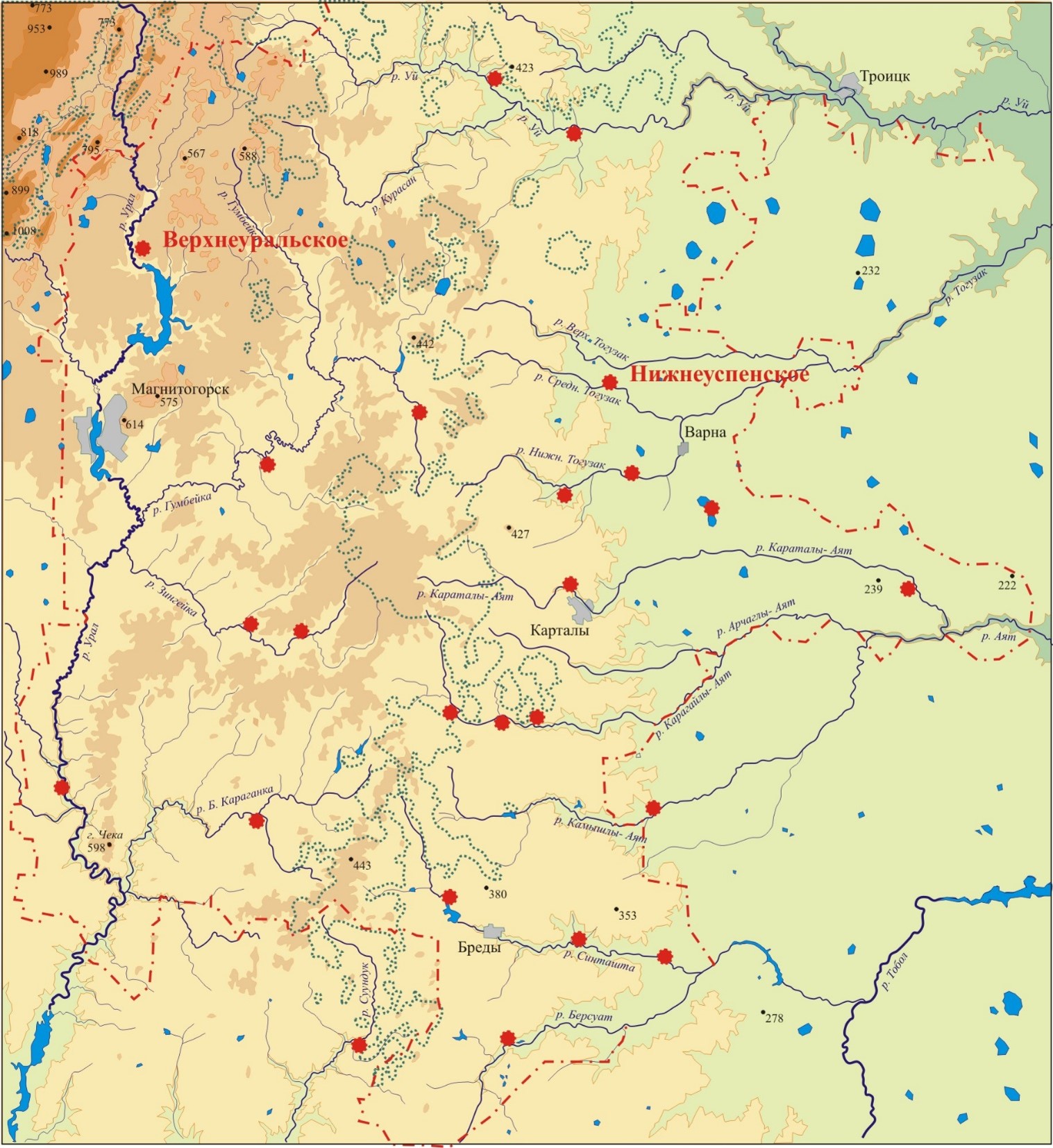
Researchers from Chelyabinsk State University, Yugra State University, and the Bulashevich Institute of Geophysics of the Ural Branch of the Russian Academy of Sciences have developed a methodology for remote search and research of archaeological sites. It represents a complex of innovative technologies, including mathematical modeling and machine learning. Using the methodology, the authors studied the Bronze Age monuments in the valleys of the Uy and Sintashta rivers: the vicinity of the ancient settlements of Stepnoye and Levoberezhnoye, as well as the recently discovered fortified settlements of Nizhneuspenskoye and Verkhneuralskoye.
As scientists told Izvestia, about 2 thousand archaeological monuments left by people for more than 100 thousand years are known in the Southern Trans-Urals. One of the most interesting stages in the history of this region is the period of the Bronze Age (the end of the third and second millennia BC), when a society of ancient pastoralists and metallurgists who spoke one of the Indo—European languages was formed here.
Experts combine the monuments of the Bronze Age into the Sintashta and Petrovsky archaeological cultures, and to the general public they are known by the conventional name "The Land of Cities". According to experts, over many decades of work, less than half of such objects have been identified and studied, since most of them are hidden by a layer of soil. At the same time, they must be searched, mapped and entered into the land registry in order to preserve them in the conditions of active construction and other economic activities of modern man.
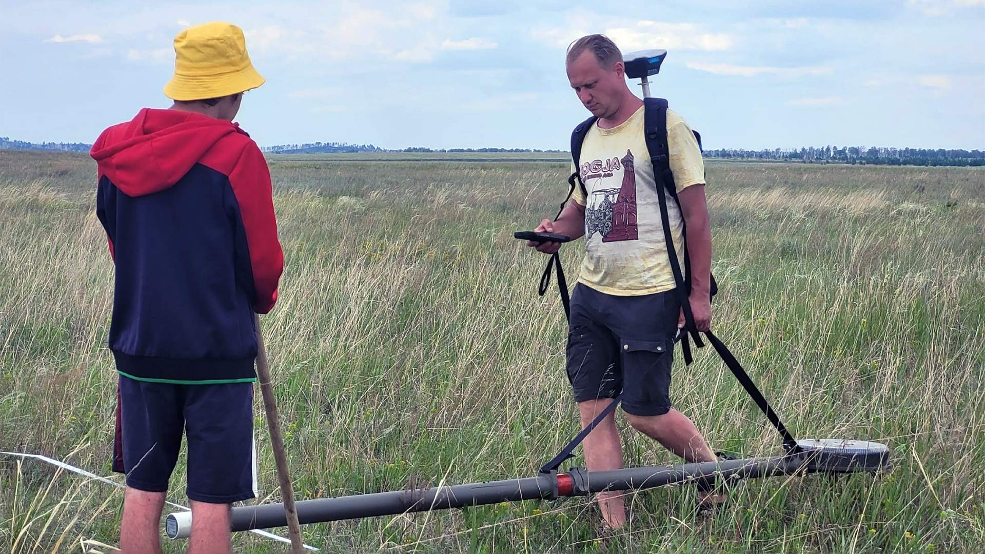
Since the end of the 20th century, scientists have been using remote methods to search for and study archaeological sites, including aerial photography, satellite imagery, and geophysical surveys. For example, magnetometry — the measurement of local magnetic field anomalies in a particular area — allows you to identify the structural elements of objects hiding underground: the remains of houses, moats and walls, burial chambers. In recent years, specialists have used remote methods to open several new fortified settlements in the Chelyabinsk Region in the northern and central parts of the "Land of Cities". However, the "manual" analysis of aerial photographs and geophysical data can take years, which makes the use of modern information technologies relevant.
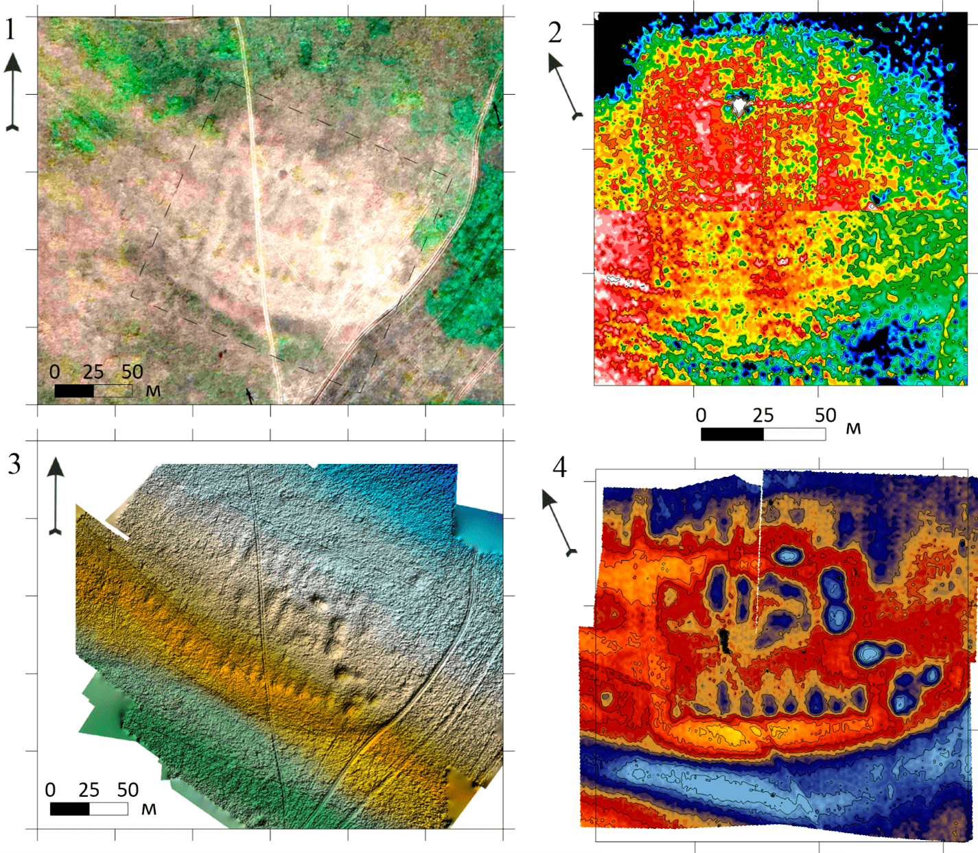
To discover new monuments and study their internal structure, the researchers used various combinations of methods. A digital 2D model of the terrain, built on the basis of satellite and aerial photographs, the results of surveying the territory using an electronic total station device, as well as electrical intelligence data, helped to detect objects underground. It allowed scientists to explore the settlement of Stepnoye, where magnetic imaging is ineffective due to natural anomalies.

The authors analyzed the 2D model of the relief of settlements using a previously developed neural network. This helped to determine the exact boundaries of the ancient settlements for further research.
— We strive to combine diverse methods of mapping, geophysics and machine learning to solve the global challenge of protecting the world's archaeological and cultural heritage. The proposed system of remote non-destructive testing can be applied in different territories. In the future, we plan to use it to study the archaeological sites of the Bronze Age of Northern Xinjiang in China, which have a similar landscape and characteristic visual and digital markers of cultural sites," said Alexander Vokhmintsev, Doctor of Technical Sciences, head of the scientific research Laboratory "Intelligent Information Technologies and Systems" at Chelyabinsk State University.
The use of AI in archaeology
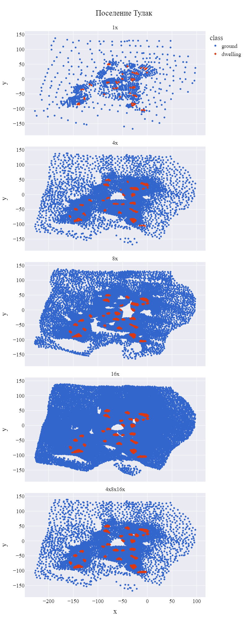
The researchers studied individual structures of archaeological sites on their detailed digital 3D copies. To form them, the scientists applied electrical exploration, and also built three-dimensional models of the landscape using aerial photography and laser scanning from the air. 3D models were analyzed using a neural network. Artificial intelligence has identified defensive fortifications, ditches, dwellings and some types of burial grounds on the settlement map with 96% accuracy. However, the accuracy of recognizing objects such as traces of wells and entrances to settlements was less than 40%, which is not enough to determine the structure of the monument without human intervention.

The scheme of the Stepnoye settlement according to the data of decoding satellite and aerial photographs in semi-automatic mode with human participation
Nevertheless, machine learning technologies have allowed us to obtain new information about the monuments of the Bronze Age. In particular, on the territory of the Verkhneuralskoye settlement, scientists have identified the remains of various buildings. So, in addition to the rectangular fortified settlement described earlier, the authors found earlier oval-shaped defensive fortifications. At the same time, in the central and eastern parts of the site, the remains of the buildings of an undefended settlement, which was erected on top of the ruins in the late Bronze Age, were discovered.

Before the development of neural networks, scientists had a big problem in systematizing data and understanding where archaeological sites are located and where modern buildings are located, Anton Averyanov, CEO of the ST IT group of companies, TechNet NTI market expert, told Izvestia. In addition, there may be practically no traces of archaeological valuables on the surface — electrical exploration and soil research save here.
— Archeology is one of those areas where the use of AI is most justified. The ability to process big data allows us to track various dependencies and predict where traces of an old civilization may be located with high accuracy," he said.
AI is proving effective all over the world: in Peru, algorithms have found hundreds of Nazca geoglyphs in months, which would take years of manual work. In Portugal, AI detects Bronze Age mounds with high accuracy from satellite images, reducing the need for trial excavations. In Madagascar, AI and LiDAR are saving monuments from erosion and logging by promptly scanning vast territories, said Yaroslav Seliverstov, a leading expert in the field of AI at University 2035.
— For the fragile monuments of the Trans—Urals, this approach is not just an innovation, but a necessity that allows us to preserve an invaluable heritage for future research. AI will not replace the archaeologist, but it will become his most powerful digital tool," he said.
The results of the study, supported by a grant from the Russian Science Foundation (RSF), are published in the Russian Journal of Earth Sciences.
Переведено сервисом «Яндекс Переводчик»
