Roscosmos has published a satellite image of fires in Transbaikalia.
In the Trans-Baikal Territory, an active spread of fires was recorded, which was confirmed by satellite data published by Roscosmos. This was announced on May 11 in the official Telegram channel of the state corporation.
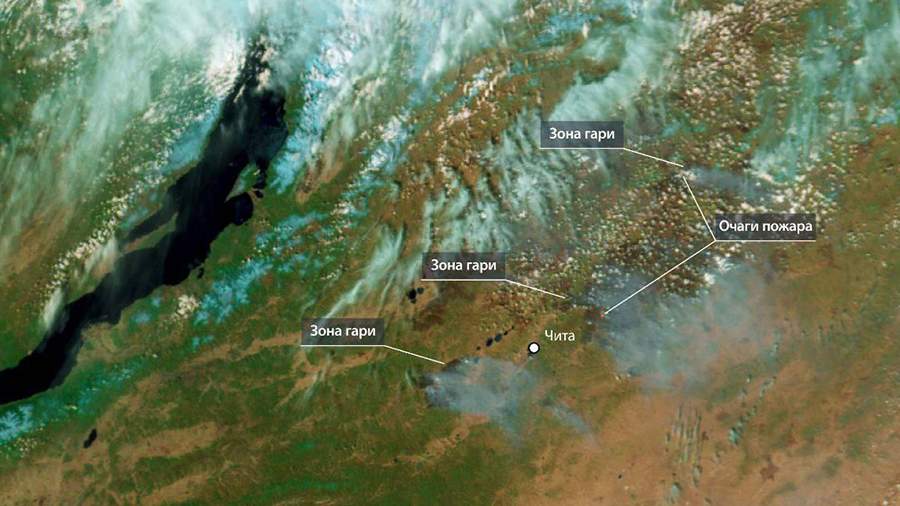
"Forests are burning in Transbaikalia. On May 9, the fire came close to the capital of the region," reads a comment under the photo on the Roscosmos channel.
The image was obtained using the Meteor-M spacecraft and the MSU-MR equipment. The image shows areas of active gorenje, as well as extensive burning areas near Chita. In addition, smoke plumes and cloud formations caused by fires are clearly visible in the image.

On the same day, the head of the third fire and rescue squad of the Ministry of Emergency Situations of Russia in the Trans-Baikal Territory, Yuri Malyukov, told Izvestia that a forest fire with an area of 1 thousand hectares was operating near the Smolenskoye rural settlement in the Chita district of the Trans-Baikal Territory.
The day before, Chita airport was closed for the release and reception of aircraft due to a landscape fire near the air harbor. The restrictions were later lifted.
Переведено сервисом «Яндекс Переводчик»
