Taking care of the frequency: scientists have found a way to improve the accuracy of navigators
- Статьи
- Science and technology
- Taking care of the frequency: scientists have found a way to improve the accuracy of navigators

For the first time, Russian scientists have calculated the conditions under which phase-locked frequency systems operate stably. These are electronic circuits that can be compared to a conductor in the world of radio signals. Their main task is to synchronize the frequency and phase of the signal coming to the device from the satellite. They are widely used in navigators and smartphones. The researchers' work will improve the performance of modern devices and create new, more accurate gadgets. For more information on how mathematics helps to reduce the error in determining location, see the Izvestia article.
Why do navigators malfunction?
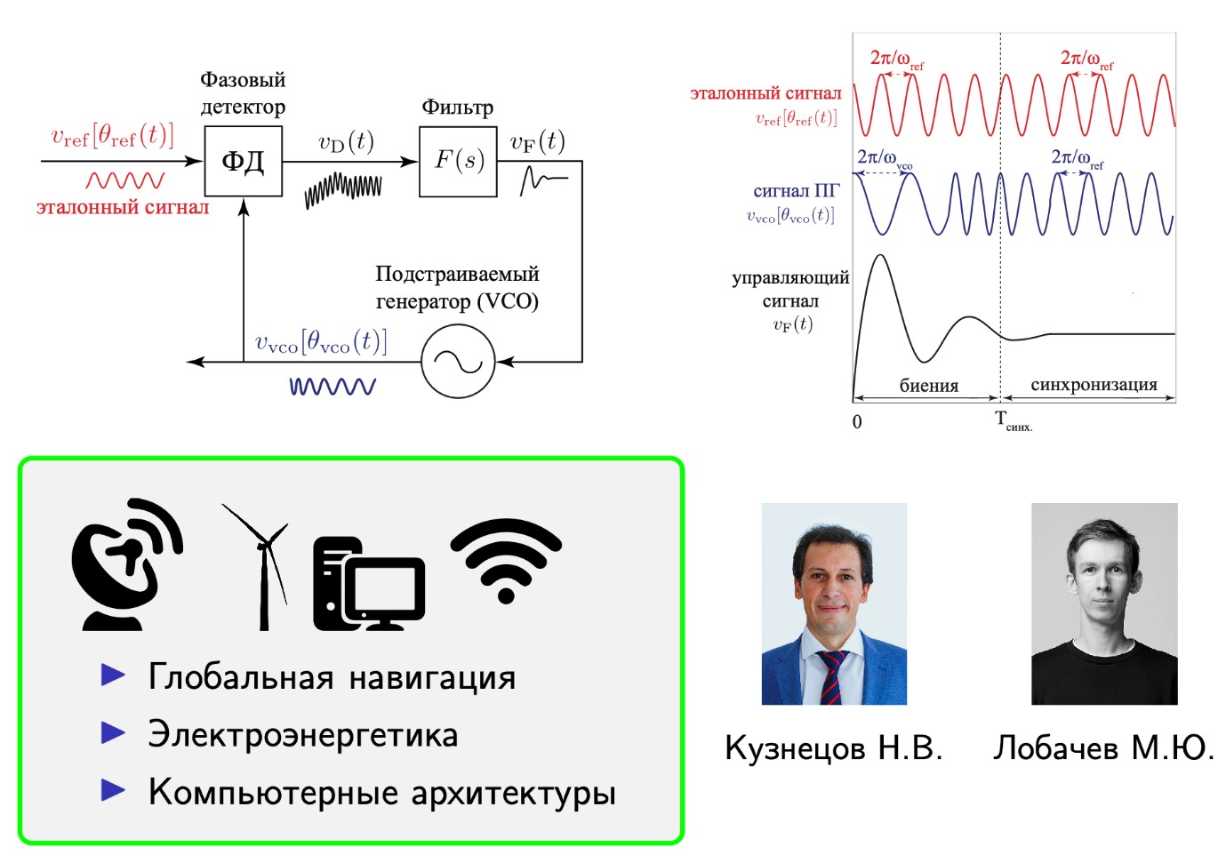
Mathematicians from St. Petersburg State University and the Institute of Problems of Mechanical Engineering (IPMash) of the Russian Academy of Sciences have identified the conditions under which three key parameters that determine the stability of phase-locked frequency systems coincide. Such systems are used in satellite navigation and communication devices and are responsible for synchronizing their signals (for example, navigator signals with satellite signals). The formulas derived by the authors can be used to adjust the instruments more precisely.
As scientists explained to Izvestia, modern electronic devices — from GPS navigators and smartphones to satellite communication devices and medical equipment - widely use phase—locked frequency systems. These are electronic circuits that can be compared to a conductor in the world of radio signals. Their main task is to synchronize the frequency and phase of the signal coming to the device (for example, for a GPS navigator, a satellite signal) and the signal generated directly on the device. This is important to do because the navigator receives satellite signals with a short delay, but an error of even one microsecond gives a location error of 300 m. When automatic systems adjust the frequency of the navigator to the frequency of the satellite, the delay disappears and the location is determined accurately.
However, it was still not completely clear under what conditions the phase-locked frequency systems still work stably, and when they start to fail. The main difficulty lies in the fact that the behavior of such systems depends on several parameters at once — retention bands, capture bands, and fast capture bands. Until now, there has been no precise mathematical description of the conditions under which the values of all three parameters coincide (this problem is known as the "Viterbi problem").
Scientists from St. Petersburg, based on strict mathematical definitions of retention bands, capture bands, and fast capture bands, have derived formulas describing the state of the system in which these three parameters coincide. To do this, the authors used mathematical tools to analyze a model system of phase frequency auto-tuning.
The calculations made it possible to determine the conditions for matching the retention, capture, and fast capture bands, as well as to develop new precise formulas for calculating stability ranges and to prove that many approximate estimates used in engineering practice can lead to errors and loss of synchronization. The researchers confirmed the obtained analytical results using computer modeling.
The hold band is the maximum frequency difference at which the system can keep in sync. The capture band is the maximum difference at which the system can enter synchronization from an unsynchronized state. The fast capture band is the maximum difference at which the system switches to a synchronized state almost instantly, without delay.
When will the navigators start working exactly
The conducted research will make it possible to improve synchronization systems in a number of key areas. Firstly, in satellite navigation (GPS, GLONASS), where a synchronization error of even nanoseconds leads to a meter positioning error. Secondly, in 5G/6G mobile communication systems, where precise matching of thousands of base stations is required. And thirdly, in the synchronization of autonomous transport sensors, where out of sync can lead to an emergency situation.
— The application of rigorous mathematical approaches to the design of phase-lock systems allows not only to significantly clarify the boundaries of the applicability of such schemes in practical applications, but also leads to the invention and patenting of fundamentally new phase synchronization flowcharts. The relevance of these works is related to the import substitution program in Russian electronics and a wide range of engineering applications," said Nikolai Kuznetsov, a participant in the project supported by an RNF grant, Doctor of Physico—Mathematical Sciences, Corresponding Member of the Russian Academy of Sciences, Professor, Head of the Department of Applied Cybernetics at St. Petersburg State University, Head of the Laboratory of Information Management Systems at IPMash RAS.
In the future, the authors plan to apply the results obtained to the analysis of more complex nonlinear phase-locked frequency systems used in computing to organize computer system components, such as registers, counters, and processors.
This study provides an opportunity to work better with GPS and GLONASS systems, in particular on mobile devices. Satellite navigation systems, namely GPS, are now used everywhere. They use mathematical models to calculate the location, said Anton Averyanov, CEO of the ST IT group of companies, TechNet NTI market expert.
— Now there is a problem that the mathematical algorithms are imperfect and scientists were able to deduce a new one that allows you to calculate the location more quickly and accurately. This makes it possible to increase the accuracy of mobile GPS on GLONASS. However, the integration of this solution will be difficult, because now all systems are integrated directly into the software by the developers of such devices. And mostly, except for GLONASS, it's all being developed abroad," the expert noted.
Reducing the time synchronization error in satellite navigation systems can be used for leak detection systems in pipelines, said Marat Khakimyanov, Doctor of Technical Sciences, expert at the NTI Thinking Club of Ufa State Petroleum Technical University.
— The principle of operation of such systems is based on the registration of pressure waves by sensors spaced in space. At the moment of leakage, a pressure wave is generated that spreads throughout the pipeline. Knowing the time intervals between the registration of pressure waves by sensors installed in different places of the pipeline, it is possible to determine the location of the leak," the expert explained.
The more precisely the sensor clocks are synchronized, the less error there will be in determining the location of the leak, he added.
Переведено сервисом «Яндекс Переводчик»
