Where is the wind blowing: how Moscow studies nature and "makes the weather"
Without a daily weather forecast, life would be even more unpredictable. However, few people ask themselves about the processes behind the dry summary, which millions of Russians and thousands of organizations receive daily, and which is done by specialists from Roshydromet and its subordinate structures. Izvestia witnessed one working day of those who make the weather for us.
Summary of the tip
Over the long history of the Russian Hydrometeorological Service, its range of activities has gone beyond the organization that issues weather forecasts for the coming days, and today it is conducted in a variety of areas. The modern Roshydromet is a huge multi-purpose research and computing complex, whose employees monitor environmental protection, engage in educational, international, publishing and museum activities. Of course, this organization also predicts the weather for different periods, from two days to several months.
The staff employs 36,000 people, and Roshydromet has 17 different research institutes and several important divisions. The main federal predictive enterprise of the Russian Hydrometeorological Service is the Hydrometeorological Center. It provides weather reports to 21 federal ministries, state-owned companies and, of course, ordinary citizens.

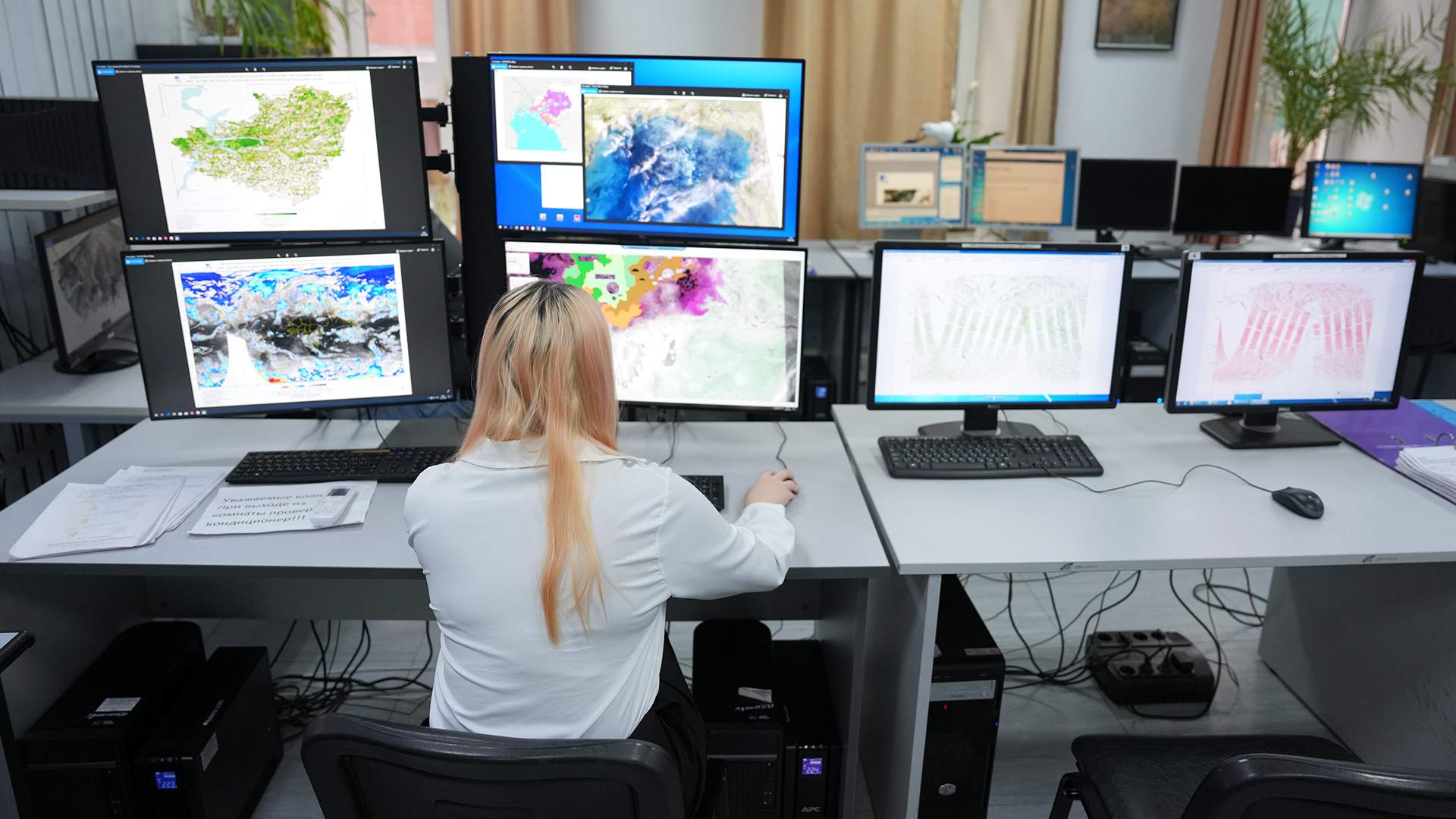
For each of the consumers of their information, the staff of the Hydrometeorological Center is able to make a weather report. Each weather forecast is made using computer programs and mathematical models, as well as manually. Operational forecaster Elena Mamysheva enters various data into a special computer program with a forecast map of the entire Northern Eurasia and Russia for the next day, which was made by a special program. Elena Nikolaevna is engaged in forecasting the weather in Moscow and the region for the next two or three days, that is, for the day after tomorrow and the day after tomorrow. She doesn't know exactly what it will be like in the end. The data on the weather map is not static and is updated every two hours. It's morning now, and the newsletter for a wide range of users and organizations should be ready by evening.

The Hydrometeorological Center does not limit itself to such operational regular forecasts. The situation center of the Hydrometeorological Center makes weather forecasts about expected life-threatening natural phenomena, such as hurricanes, abnormal air temperatures, critically high precipitation, and so on for several days ahead for both Moscow and the Russian regions. Thus, the situation center of the Hydrometeorological Center ensures the meteorological safety of the state and the protection of Russians from dangerous weather events.
— The situation Center is a department of the Hydrometeorological Center of Russia. Information about possible dangerous weather events actually and expected flows here, and crisis management takes place in close contact with colleagues from other departments, primarily from the Ministry of Emergency Situations, — says Irina Makarova, a leading meteorologist at the Hydrometeorological Center of Russia.

A map of Russia with extreme weather events is being prepared in the Meteorological Warning system. To the unsophisticated eye, it resembles a school contour map, but in fact it is a complex information matrix. All those dangerous phenomena that are expected on the territory of our country, as well as on the territory of our neighbors, in particular in the Republic of Belarus, the countries of Central Asia, Europe and other countries, are indicated in different colors. The color determines the speed and gusts of wind for the next two days. For example, in Transbaikalia, judging by the map, on the day of our visit there is a strong wind with gusts up to 25 m/ s, this is already considered a storm warning, this subject of the federation is painted orange.
But most of the country's territory is painted green on the map, which indicates the absence of abnormal weather events. Part of the northern regions is painted yellow: here the weather can become potentially dangerous. The wind does not always blow only in the northern regions. In early March, the Moscow region was marked yellow, and for a couple of days it even turned orange. The program usually colors the highest danger level in red.

— Fortunately, there has never been a "red" weather hazard level in Moscow in the entire history of meteorological observations. Looking at this map, we can see that an atmospheric front with precipitation is passing through the south of the entire European territory of Russia. But we can tell how the weather will change in the coming days. And we know what weather values will be predicted, all this helps weather forecasters, who are already issuing an official warning forecast and communicating it to every department on the ground," says Kirill Tudri, deputy head of the Hydrometeorological Center.

Kirill Tudri, Deputy Director for Scientific Work at the Research and Operational-methodological institution of the Russian Hydrometeorological Service in the field of hydrometeorological forecasts
As a rule, all weather extremes, such as frosts or abnormal heat, are indicated in these reports, forecasters say.
— During seasonal weather events, if necessary, colleagues from other government departments, such as the Ministry of Natural Resources and its structures, are also involved in consultations. At the height of the fire season, we cooperate with specialists from the Federal Forestry Agency and the Aviation Environmental Protection Agency for consultations, and in case of floods or during floods, with specialists from Rosvodresurs," says Irina Makarova, a leading meteorologist at the Hydrometeorological Center of Russia.
How data is collected
Here, a forecast is made for medium-term temperature, expected precipitation and wind strength for the coming month, as a rule, it is fully ready on the last working day of the previous month. And if these forecasts are common practice, then accurate forecasts in winter, what the summer will be like, or in summer, how cold the winter will be, will not be made so much in advance, because there is still no special equipment capable of detecting weather phenomena over such a long period of time.
Data on temperature, atmospheric pressure, speed and wind gusts, on the basis of which forecasts are made, flow to the Hydrometeorological Center from special sensors located all over the planet. The Hydrometeorological Center shares its information with colleagues in other countries, because it has been a member of the world meteorological center since 1964. This connection helps to predict changes in weather conditions more clearly. After the weather data is received, it is processed in two stages. As a result of their initial analysis, a so-called atmospheric global model is being prepared, which is a map of Russia, it is sent to the regional offices of the organization (there are 28 of them), and regional atmospheric models are already being made on its basis.

Weather data packets are also collected from space satellites and from aerological stations that are launched into the atmosphere from Earth. Such stations are equipped with radar, with their help meteorologists measure wind speed, temperature, pressure and humidity in the atmosphere up to a height of 30-40 km, and every few seconds data is transmitted from the sky to the Ground on how atmospheric processes change with altitude. From the outside, such a device looks like an ordinary balloon, but in fact a meteorological radiosonde is attached to it, which makes measurements.
— There are many such aerological stations in Russia, 112 units. We have one of the largest networks in the world. The weather data in the Moscow region is read by the only station located in Dolgoprudny, the northernmost station is located on Novaya Zemlya, the southernmost is in the Krasnodar Territory, and the eastern is in Chukotka," says Kirill Tudriy.

Thanks to such stations, meteorologists understand what is happening in the upper and lower layers of the air. Terabytes of data are transmitted to this organization per day, which are rechecked several times, then automated data is monitored for greater accuracy, then the system rejects information that seems viral to it. Then the systematization and unification of meteorological data on temperature, pressure, precipitation is launched, and based on them a mathematical meteorological model is made for the atmospheric region monitored by an aerological station.

One of the scientific divisions of Roshydromet, the Federal State Budgetary Institution NIC Planeta, monitors from space and makes satellite maps with various functions. This organization is preparing systems for monitoring on water, in the air and on land for further production of maps using various satellites. For example, polar-orbiting satellites move along a specially set trajectory and take pictures of the Earth from different points on a schedule. Other geostationary satellites, on the contrary, are static and take pictures of the Earth from only one point every 15 minutes, and then wirelessly transmit a new photo to the NIC "Planet".
— Maps of ice, fire, flood conditions and many others are made from these images, — says Tatiana Kormashova, head of the department at the Federal State Budgetary Institution NIC Planeta.
Roshydromet is looking for talents
In addition to the strategic goals of the Federal State Budgetary Institution "SIC "Planet" there are also applied ones. This structure works around the clock, and the lives of its employees would be much more difficult if about half of the maps were not made by computers in automatic mode. Thanks to new technologies, people in this organization can monitor the current weather processes in the Arctic, the Far East or Siberia in almost real time, predict the emergence of cold fronts and draw their own conclusions. The satellites allow the staff of the Scientific Research Center "Planet" to assess the thickness of the ice and the slightest changes in the Earth's atmosphere thousands of kilometers from Moscow at a single point.

A slide with snow gusts over the northern seas flickers on the monitor screen, and Ekaterina Frolova, head of the space meteorology department, can analyze how dangerous such processes are for the general meteorological front.
— The transmission of such data from cold spots to the structure of the Russian Hydrometeorological Service has become more reliable thanks to the Arktika M spacecraft, which was launched in 2021 and 2023. Thanks to it, you can quickly track many meteorological processes. Do you see these stripes? This is a cyclone over the Barents Sea. It used to be difficult to track this. And now, yes, says Ekaterina Frolova.

The main computing center in the building of the scientific research and operational methodological institution of the Russian Hydrometeorological Service in the field of hydrometeorological forecasts
Terabytes of this information are stored in the next room, buzzing like a swarm of bees, packed from top to bottom with servers. After all, natural phenomena are one of the most changeable things in the world, and the task of the staff of Roshydromet is to monitor any changes in the environment.

Like many structures, Roshydromet is experiencing a small, but still personnel shortage, despite the fact that it is possible to get an education to work in this structure in dozens of educational institutions in the country. "We lack weather forecasters, meteorologists and IT specialists," says Kirill Tudri, Deputy director of the Hydrometeorological Center of Russia.
But that's a completely different story.
Переведено сервисом «Яндекс Переводчик»
